News

Article

iLand Projects Software Gets Mapping and ROC Log Export

Aug 20 2015 | Product News

UPDATE iLand has been renamed to Pandell Projects

Calgary, AB – (Aug 20, 2015) Pandell announces the release of version 3.7 of its iLand software for land acquisition project management. This version includes a project mapping tool and a ROC Log government export.

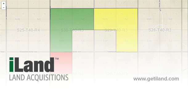
  • Project Mapping – iLand users can now see all of their project and sub file data plotted on a colour-coded land parcel map. Parcel colours reflect the current status of a project, giving acquisition teams a visual snapshot of work in progress.

  • ROC Log Export – iLand now exports a First Nations Record of Consultation Log that conforms to the required Alberta Government template. The automatic export streamlines reporting obligations and reduces potential for errors.

About iLand

iLand is land acquisition project management software that gives Brokers and Producers the ability to track, communicate, and report real-time details of a project, securely over the web. It provides a collaborative hub where stakeholders can go to record, edit, and view project updates, and generate all necessary surface acquisition documents. To learn more or to request a demo, please visit Pandell Projects.


View More Pandell News

About Pandell

Pandell is an industry leader in delivering Software-as-a-Service (SaaS) solutions to 500+ energy companies in Canada, the USA, and abroad. Our customers range from startups to major enterprises across energy sectors including oil & gas, pipelines, utilities, mining, and renewable energy. Our cloud-hosted product suite helps finance, land, and field operations run their business more effectively; while our enterprise division builds and manages large-scale web portal applications that facilitate work across organizations. Combining the strength of our industry experience, Lithium™ technology, and practical software subscription model, we are Crafting the Future of Energy Software.

Social and Info

Our Latest Posts Pandell's LinkedIN

We had an amazing time connecting and golfing this week at #IMGIS2025 in Palm Springs! ⛳

Some of our customers who integrated Whitestar’s clean, standardized land data into their Pandell land system saw up to 80% less time spent on land administration, a true game changer for efficiency.

Pandell’s Enterprise Land unifies land workflows and geospatial data in one system. And since Pandell and Whitestar have been Esri partners for years, everything works seamlessly with the GIS tools your team already knows and trusts.

If you missed us and want to learn how to step up your land management, reach out, we’d love to connect!

#Esri #EsriPartner #GISMapping #LandManagement #GeospatialData

The latest McKinsey & Company Global Energy Perspective reveals that global energy demand continues to grow, even as decarbonization efforts accelerate. From regional shifts and rising electricity needs to the ongoing role of fossil fuels, the report highlights both opportunity and urgency for the energy sector.

Read more: https://hubs.ly/Q03PWX3K0

As the energy landscape evolves, our integrated land and financial software helps companies to plan, track and manage their business operations more efficiently.

#EnergyTransition #GlobalEnergy #Utilities #RenewableEnergy #OilAndGas

⚡Are your data systems holding your energy operations back?

As energy companies grow and adopt new technologies, managing data across multiple vendors can quickly become a major challenge. Disconnected systems lead to inefficiencies, higher costs, and slower decision-making.

Our article explores how integrated data management platforms can help unify information, break down silos, and deliver real-time insights for better, faster decisions.

👉 Read more: https://hubs.ly/Q03PxBwV0

#EnergyIndustry #DataManagement #DigitalTransformation #EnergyInnovation #Utilities #OilAndGas #Renewables

Exhibiting at Electricity Transformation Canada 2025 last week in Toronto was a blast! We loved exchanging ideas on how renewable energy companies can transform their land management. It was great to show how quickly land teams can access information by bringing all their land data into an integrated solution.

Check out Pandell LandWorks https://hubs.ly/Q03NCwSd0

#LandManagement #RenewableEnergy #CleanEnergy #ETC2025

It was so much fun sponsoring the Masquerade Ball at the Canadian Association of Land and Energy Professionals Conference last week in Saskatoon!

Unmask your land data with confidence - our experts guide you from start to finish.

Pandell Projects - where energy operators and land services partners can track, communicate and report land acquisition project details in real-time. https://hubs.ly/Q03NHZtc0

#LandManagement #CALEP2025 #LandAndEnergy #EnergyLeadership

Good land data is important. Great land data transforms.

Some of our customers started using Whitestar’s clean, standardized land data in their Pandell land system, and they saw up to 80% less time spent on land admin.

Pandell’s Enterprise Land brings your land workflows and geospatial data together in one system. And since Pandell and Whitestar have been Esri partners for years, it all works seamlessly with the GIS tools your team already knows and trusts.

Curious how it works? Watch the video below to see how better data leads to faster, smarter decisions.

Heading to #EsriIMGIS2025 in Palm Springs (Oct. 28–30)? Come say hi at Booth #528 or catch us at the golf tournament—we’d love to connect.

#GeospatialData #EnergyGIS #LandManagement #EnergyLand #LandSoftware #EsriPartner

We're excited to be exhibiting at Electricity Transformation Canada 2025 this week in Toronto, ON!

No Tricks, Just Treats With Pandell Land! 🍬 Stop by booth #727 to chat with our team and discover how we're transforming land management for renewable energy.

#ETC25 #LandManagement #RenewableEnergy #CleanEnergy #CanREA

View All Pandell Posts